Using the Atacama Pathfinder Experiment (APEX), a 12-m radio telescope at 5,100 m altitude in the Chilean Atacama desert, astronomers have mapped the full area of Milky Way’s Galactic plane visible from the southern hemisphere at submillimeter wavelengths.

Milky Way’s Galactic plane: the APEX data, at a wavelength of 0.87 mm, shows up in red and the background blue image was imaged at shorter infrared wavelengths by NASA’s Spitzer Space Telescope as part of the GLIMPSE survey. The fainter extended red structures come from complementary observations made by Planck. Many of the most prominent objects are named and the parts of the Galaxy that are shown in the three slices are indicated at the right. Image credit: ESO / APEX / ATLASGAL Consortium / NASA / GLIMPSE Consortium / ESA / Planck.
APEX is a collaboration between the Max Planck Institute for Radio Astronomy, the Onsala Space Observatory and the European Southern Observatory (ESO).
The APEX Telescope Large Area Survey of the Galaxy (ATLASGAL) took advantage of the unique characteristics of APEX to provide a detailed view of the distribution of cold dense gas along the plane of our Galaxy.
The new image includes most of the regions of star formation in the southern Milky Way.
“ATLASGAL provides exciting insights into where the next generation of high-mass stars and clusters form,” said Dr. Timea Csengeri, of the Max Planck Institute for Radio Astronomy in Bonn, Germany.
“By combining these with observations from ESA’s Planck satellite, we can now obtain a link to the large-scale structures of giant molecular clouds.”
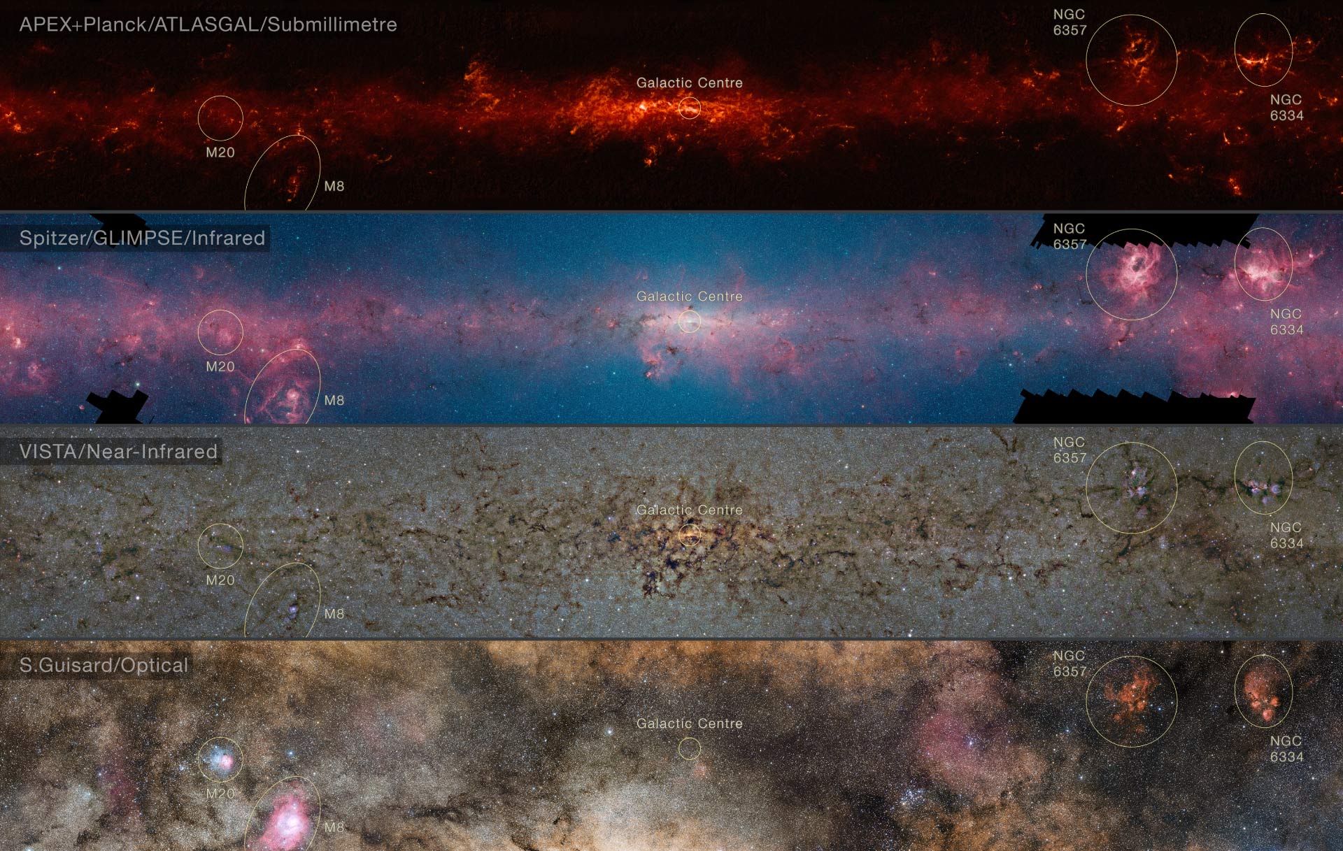
This comparison shows the central regions of the Milky Way observed at different wavelengths. The top panel shows compact sources of submillimeter radiation detected by APEX as part of the ATLASGAL survey, combined with complementary data from ESA’s Planck satellite, to capture more extended features. The second panel shows the same region as seen in shorter, infrared, wavelengths by NASA’s Spitzer Space Telescope. The third panel shows the same part of sky again at even shorter wavelengths, the near-infrared, as seen by ESO’s VISTA infrared survey telescope. Regions appearing as dark dust tendrils here show up brightly in the ATLASGAL view. Finally the bottom picture shows the more familiar view in visible light, where most of the more distant structures are hidden from view. The significance of the colors varies from image to image and they cannot be directly compared. Image credit: ESO / ATLASGAL Consortium / NASA / GLIMPSE Consortium / VVV Survey / ESA / Planck / D. Minniti / S. Guisard / Ignacio Toledo / Martin Kornmesser.
The ATLASGAL maps cover an area of sky 140 degrees long and 3 degrees wide.
“ATLASGAL has allowed us to have a new and transformational look at the dense interstellar medium of our own Galaxy,” added Dr. Leonardo Testi of ESO.
“The new release of the full survey opens up the possibility to mine this marvelous dataset for new discoveries.”
“Many teams of scientists are already using the ATLASGAL data to plan for detailed ALMA follow-up.”